Wednesday, March 24, 2010

South Branch Pond

This place is a must-see for any person that visits Baxter State Park. I grew up next to the North Enterance to the park, and my family spent a lot of time here during the summer. If you are looking for a spot to go in the park and do a wide variety of activities within a short amount of time, this is the place. This site has many camp sites - tent sites, lean-tos, and cabins - but it is such a popular destination that in order to get a reservation you must mail-in or walk-in at least 4 months prior to the date you would like to camp there.

Swimming/Canoeing
The water in South Branch Pond is so clear that some days you can see right to the bottom, so this is a prime place for swimming on a hot day. If you like canoeing or kayaking, the pond is large enough for both and for a small fee visitors can rent a canoe from the park (I believe it is only $2.00 an hour). The ranger station even has it's own supply of life jackets for those visitors wanting to get out on the water. If you take your canoe across to the side of the pond opposite the docks, you will find a small stream connecting the upper pond and the lower. When I was in high school, my best friend and I came up this way in a canoe and jumped from the cliffs at this pond. I'm going to say "Don't try this at home" because I don't want some slap-happy tourist taking the jump and then suing me for damages. So - partake in this activity AT YOUR OWN RISK. There - glad that's out of the way :)

Hiking

There are many different hiking trails around South Branch Pond, and no matter what level of difficulty, how long you want the hike to be, etc - you will always find something for you. Here are several of the hiking trails that you can find around the pond. Some I have been on and some I have not, but all of them are worth a look. :)

Howe Brook

This trail winds around the left side of the pond. Follow the road until you reach the Pogy Notch Trail. This trail ultimately leads to Russell Pond, but you will see several other hikes listed on the same sign - one of these is Howe Brook. The hike is only about four miles round trip, and the terrain makes for an easy, leisurely hike. Once you reach brook, the trail follows it upstream and passes a series of pools and waterfalls. This is a great hike to start on in the morning during the summer, as the pools and waterfalls make for a nice place to stop and eat lunch before turning around and heading back to the campground for a dip in the pond. :) If you're daring enough to brave the ice cold water flowing straight off the mountain, some of the pools at Howe Brook are big enough to swim in - but take it from my first-hand experience....even in a heatwave in August, they are ice cold!


South Branch Falls
This waterfall is not very big, but it's a great place to check out because there are usually not many people there. If you want a little more out of the way place to have a moment of peace and quiet with nature, try taking a side trip down this trail. Once you park at the campground, you will need to hike back up the road you came down a piece to get to the trail-head. The hike is only about 2 miles round trip, and it's a very easy hike for people of all ages. Although the waterfall is small enough that it seems very inviting to take a dip and play - keep in mind that there are a LOT of spiders making their home in the rocks. While Maine does not have poisonous spiders - not many would want to go swimming even with harmless ones. ;)

North Traveller Mountain
To get to the trail head for North Traveller, take the Pogy Notch Trail. A short distance down the trail, you will find the sign for North Traveller directing you to the left and up the mountain. This hike will take the better part of the day. Even though the trail is only 2 miles to the mountain top, the mountain itself is over 2500 feet. This steep incline makes the hike more challenging than it's short distance implies. Most of the trail is exposed, but as a result this makes for many impressive views with the most breath-taking being the view from the summit. Once you reach the peak of North Traveller, you have a clear view across the valley of Knife's Edge on Katahdin. Bring plenty of water when making this climb, and be sure to check out the spring part way up the mountain (clearly marked by the park with signs). When I first hiked this mountain, I was just in grade school and was maybe 10 years old. So if you have a fit grade-schooler and the conditions are good, you should be able to make this hike. Any younger children would probably have difficulty with this one, though. The last time I made this hike, I was 17 years old, and it's been far too long since I've been back! Believe it or not, you are going to have to wait for photos from me because I can't find ANY photos to put on here that I like! haha

There are many more hiking trails to check out around South Branch, and as I explore them - I will definitely pass them along. But for now, this is all you get ;)

Tuesday, March 23, 2010

The Bold Coast - Cutler Preserve

This hike caught my eye because it travels along 100ft cliffs on the coast, and it would be easy to make a full day of this hiking trip. According to what I've read, the 5.8-9.8 mile loop (depends on the route you take) includes barrens, bogs, maritime forests, and a completely exposed hike along the coastal cliffs. In late summer and early fall, whales can sometimes be seen passing through the Grand Manan Channel on this hike. This really makes me want to wait until late August or September to make this hike, as it would make the trip just that much more awesome to get to see the whales from the cliffs.

Evan's Notch - Blueberry Mountain Loop
This is a moderate 4.5 mile loop hike in the Maine portion of White Mountain National Forest. It is said that it is a particularly beautiful hike during the fall when the foliage begins to change. The hike includes a small gorge known as Rattlesnake Flume, and a popular swimming hole known as Rattlesnake Pool. Although the names do not sound very inviting, be assured - there are no poisonous snakes in Maine :)


Evan's Notch - The Roost
I was thinking it would be a good idea to go on a weekend trip and combine the climb up the Blueberry Mountain Loop with the climb up The Roost. This is a shorter hike of about 1.2 miles that brings you to a view of the Wild River Valley with views of Grafton Notch and Mahoosuc Range. A weekend trip when the foliage changes would make for some spectacular photos!


Mahoosuc Notch
This 6.5 mile round trip hike is considered a difficult hike and has been referred to as "The hardest mile on the Appalachian Trail". This hike includes climbs over boulders and through caverns as you make you way through the notch. Hikers need to pay careful attention to their footing (especially when the terrain is wet) as the terrain is very uneven. What caught my eye about this hike were the massive rock formations on the trail that were created when the glaciers receded from the area during the last ice age (see photo).


Mount Kineo
This is a kayak/hiking trip on Moosehead Lake (the largets lake within one state east of the Mississippi). The hike itself is only about 4 miles round trip, but the only way to the mountain is by water. It is on an island in the middle of Moosehead Lake. You can either paddle across yourself from Rockwood or be ferried over by the Kineo Boat Launch which departs from 8am to 5pm on the hour. If you do not have your own kayak, rentals are available right in Greenville. Not only does this climb boast 800ft cliffs, but once you reach the top of Mount Kineo, there is a restored look-out tower which offers a 360 degree view of Moosehead Lake. Henry David Thoreau made two trips to Mount Kineo and had this to write about it - "The celebrated precipice is so high and perpendicular that you can jump from the top, many hundred feet, into the water which makes up behind the point. A man on board told us that an anchor had been sunk ninety fathoms at its base before reaching bottom! Probably it will be discovered erelong that some Indian maiden jumped off it for love once, for true love never could have found a path more to its mind." This is now one of the trips I am most excited for.

Gulf Hagas
This is probably the one trip that I have been waiting all winter to be able to make. I first heard about the "Grand Canyon of the East" from my soccer coach at University, but at the time I was so caught up in other things that I did not pay it much mind. This winter, it suddenly came back to me, and I started doing research. Gulf Hagas is near Brownville Junction in the 100-mile Wilderness (the most remote section of the Appalachian Trail), and once this wild landscape was also home to Katahdin Ironworks. Iron ore was mined from nearby Ore Mountain and brought here to be turned into pig iron. The iron works succumbed to outside competition and closed in 1890, but you can still see remnants of the blast furnaces used to super heat the ore. The 8 mile loop hike is considered moderate to difficult, and includes side trips to many waterfalls and pools. A site referred to as "The Hermitage" is home to a stand of old growth white pines (see photo).

South Turner Mountain/Sandy Stream Pond
This hike is considered by many to be a great introductory hike to Baxter State Park. It is located at the South Enterance, and it is a good idea to come early because when the parking lot is full - there are no more hikers allowed on the mountain. While South Turner offers a great view of Katahdin, it is from the Millinocket side - and the best view (by a long shot) can be found from the other side of the mountain (try the North Traveller hike for this one). I will say that it is the view that has caught my eye for this hike, though. It offers great views of Russel Pond, Whidden Pond, Basin Ponds, and Little North, South and Great basins of Katahdin. It is a moderate 5.5 mile hike where a camera is a must have.

Monday, March 22, 2010

Adventures in My Own Backyard

So I've been getting all stoked for summer all through this winter, and I figure I'll just put down some of the "adventures" I want to take right here in Maine. Maybe if I share, other people will want to give it a try, too? :) I'll probably blog about the trips as I take them, too, to give an idea of what each trip was like. These are in no particular order because I'm pretty much going to just randomly pick one each weekend :) haha


Saco Heath Preserve
This place sounded kind of cool because it has a "floating" boardwalk over a peat bog. It just seemed like a pretty unique and interesting place. While I wouldn't make the trip to Saco just for the hike, I would like to check it out on my way through - maybe on one of my trips to Boston. What is so unique about this place is that it is one of the few places that you can actually (sort of) explore a peatland bog. Most bogs are too soft on the surface to support a person's weight, and even in this preserve it is important to stay on the boardwalk path - according to the following website, there are some stories of people stepping off the path and sinking out of sight in the "Bottomless" bog. For more information, check out http://www.sacobaytrails.org/sacoheath.shtml.


Salmon Falls River

I'd like to kayak this 6 mile round trip at some point this summer, too. It's supposed to be an easy kayaking trip that takes only 2-3 hours, so it would make for a nice afternoon trip on a weekend camp out. :) There is a historic mansion (The Hamilton House) and a state park (Vaughan Woods Memorial State Park) on the riverside during this trip. So it is possible to make a day of it, as well. The Hamilton House is open Wednesday through Sunday from June 1st to October 15th, and the tours are every hour on the hour. There are also summer concerts most Sundays - which sounds like it would be very cool to check out. :) For more information on the Hamilton House, check out http://www.historicnewengland.org/visit/homes/hamilton.htm.


Monhegan Island


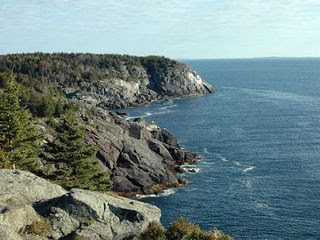
This island is 12 miles off the coast of Maine, so you have to go by boat to get to it (Monhegan Boat Line departs 3 times a day from Memorial Day to Columbus Day). Once you get to the island it's only about a square mile, but it somehow manages to pack up to 7 miles of hiking trails into the island. They do not allow camping on the island, but there are guest houses and inns on the island - and surprisingly they are not as expensive to stay in as you would think if you choose to stay at the Monhegan Inn (which I would LOVE to do! haha). The photos of the hiking trails on the island are breath-taking, and I can't imagine what it would be like to experience it first hand. It seems like it would be a much better trip than Bar Harbor! For more information check out http://www.monheganwelcome.com/index.html.

Megunticook Lake/Fernald's Neck Preserve

This is another kayaking one that I want to check out (hopefully my parents are open to me borrowing their kayak? haha). It's a 3-7 mile round-trip paddle that takes about 3-4 hours near Camden, ME. The preserve is actually on a large island in the middle of the lake, and what caught my eye about this trip was something called "Balance Rock" (see photo). For more information on Fernald's Neck Preserve, check out http://www.coastalmountains.org/conserved_lands/preserves/fernald.html.


The Beehive and The Bowl - Acadia National Park


This is supposed to be a pretty difficult climb due to the steepness of the trail and the exposure while climbing, but it sounds like an awesome challenge so I am all for it! The trip is only 1.3 miles, but it takes about an hour to do because of the degree of difficulty. The Beehive is the name of the climb to get to The Bowl (which is a pond at the top of the climb). The Bowl is one of only two ponds in the park that is accessible only on foot. Once you reach the top of The Beehive, there is a great view of Sand Beach. The trail quickly rises to meet the cliff wall and continues almost straight up with iron rungs and ladders to aid the climb. The Bowl is what is called a "tarn" - which is a pool that forms when glaciers melt. It covers about 9.5 acres at the top of the Beehive trail. For more information on The Beehive Trail and The Bowl check out http://www.acadiamagic.com/beehive.html
I will write more about my plans for the summer as I get time, and starting probably around about the end of May, start watching for posted photos and first hand accounts of all of these places :)